
Where is the Strategic Petroleum Reserve stored?
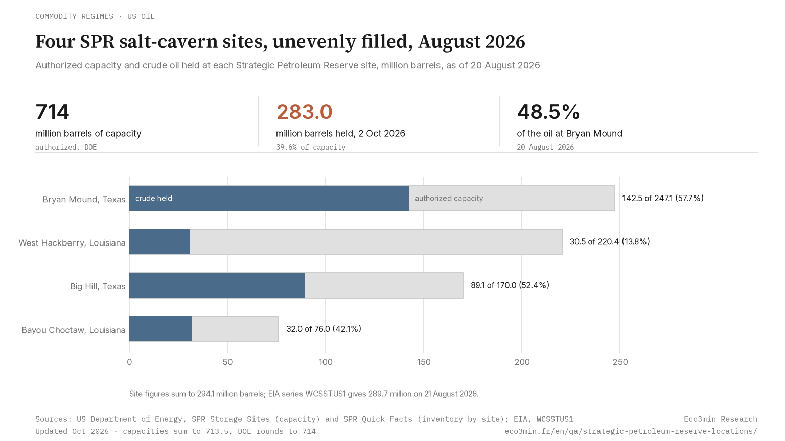
The SPR sits in salt caverns at four sites in Texas and Louisiana, with 714 million barrels of authorized capacity per the DOE. Stock by site, August 2026.
According to the Department of Energy, the Strategic Petroleum Reserve sits in salt caverns at four Gulf Coast sites: Bryan Mound and Big Hill in Texas, West Hackberry and Bayou Choctaw in Louisiana. Most caverns were dissolved out of salt domes with fresh water, their floors typically 4,000 to 5,000 feet below ground, and the oil is pushed out by water pumped in beneath it. On 2 October 2026 the reserve held 283.0 million barrels on EIA data, 39.6% of its 714 million barrels of authorized capacity, and the DOE’s latest count by site put almost half of the oil at Bryan Mound.
In this article
The short answer
Four salt domes on the Gulf Coast hold the nation’s emergency oil. Bryan Mound and Big Hill are in Texas, near Freeport and Beaumont, and West Hackberry and Bayou Choctaw in Louisiana, near Lake Charles and Baton Rouge. The Department of Energy’s page on the storage sites puts their combined authorized capacity at 714 million barrels, with Bryan Mound the largest at 247.1 million.
The reserve is not a string of tank farms across the country. Its oil sits in salt caverns, which the DOE says cost up to 10 times less than above-ground tanks. On 2 October 2026 the caverns held 283.0 million barrels, according to the EIA’s weekly series WCSSTUS1, or 39.6% of capacity.
Almost half of the oil is at one site. The DOE’s latest breakdown, dated 20 August 2026, put 48.5% of the stock at Bryan Mound. Two earlier sites, Sulphur Mines and Weeks Island, were decommissioned in 1992 and 1996.
→ Why the reserve exists: the 1973 oil shock
Bryan Mound, Big Hill, West Hackberry, Bayou Choctaw: what each site holds
The DOE’s storage sites page gives capacity and caverns, its Quick Facts page the oil at each site on 20 August 2026.
| Site | State | Caverns | Authorized capacity (million barrels) | Oil held on 20 August 2026 (million barrels) | Filled |
|---|---|---|---|---|---|
| Bryan Mound | Texas | 19 | 247.1 | 142.5 | 57.7% |
| Big Hill | Texas | 14 | 170.0 | 89.1 | 52.4% |
| West Hackberry | Louisiana | 21 or 22 | 220.4 | 30.5 | 13.8% |
| Bayou Choctaw | Louisiana | 6 | 76.0 | 32.0 | 42.1% |
| Total | 60 or 61 | 713.5 | 294.1 | 41.2% |
Eco3min calculations on the DOE table:
- Texas holds 58.5% of the capacity and 78.7% of the oil.
- Fill rates run from 57.7% at Bryan Mound to 13.8% at West Hackberry, the second-largest site.
- Capacity was 727 million barrels when the reserve was full on 27 December 2009. The 2016 review attributes the 13.5 million lost to two caverns taken out of service in 2014.
The DOE’s own figures diverge. Its web pages print 714 million barrels, but the site capacities sum to 713.5 million barrels, the figure in its fact sheet of August 2025: a rounding. The storage sites page and the 2016 review, which counts operational caverns, give 21 caverns at West Hackberry and 60 in all, the Quick Facts table 22 and 61.
Summed, the inventory by site comes to 294.1 million barrels, 4.4 million above the EIA’s 289.7 million of 21 August 2026 and closer to its 293.4 million of 14 August 2026. Neither agency explains the cavern count or this gap. On 2 October 2026, the DOE’s national total and the EIA’s matched at 283 million.
→ The national total: how the reserve’s stock has moved since 1977
Why all four Strategic Petroleum Reserve locations are on the Gulf Coast
Geology and plumbing drew the map. The 1977 plan, as summarized in the DOE’s Long-Term Strategic Review of August 2016, chose the Gulf Coast for salt domes cheaper than above-ground storage, for its refining centers and for its pipelines to Midwest refiners.
Salt as the container. In solution mining, fresh water pumped down a well dissolves the salt, about 7 barrels of water for each barrel of space. A typical cavern is about 200 feet wide and 2,500 feet tall and holds 10 million barrels. To draw oil out, water is pumped into the bottom and the lighter crude rises.
Pipes to the refineries. Seaway serves Bryan Mound, Texoma serves Big Hill and West Hackberry, Capline serves Bayou Choctaw. The DOE’s fact sheet counts links to 24 Gulf Coast and 6 Midwest refineries and 4 marine terminals.
That network was drawn for an importer.
Pipelines that changed direction. In 1977, when the first oil arrived, the United States imported a net 8.57 million barrels a day of petroleum. In 2025 it exported a net 2.85 million, on EIA data, after the shift from importer to net exporter. The 2016 review traces new lines bringing Permian, Eagle Ford and Cushing crude to Houston. Measured against the reserve’s design drawdown rate, the capacity of the pipelines, docks and refineries physically open to SPR oil fell from 142% in 2012 to 113% in 2014, and to 99% on Texoma, where the review blames falling imports.
By regime, the same sites have played two roles. Until about 2011 they served an importer: the first target of 500 million barrels was sized on 1974–1975 import levels, and oil could travel inland. By 2016 domestic crude filled the coastal pipelines, and since the 2015 repeal of the export ban buyers can ship SPR barrels abroad. The transition parameter is the direction of pipeline flows; on the trade balance, 2020 was the first full year of net petroleum exports.
The reserve was put where imported crude landed, and the pipelines around it now carry American crude to the coast.
→ Framework: structural signals in commodity markets
What it means for different economic actors
Refiners. They are the reserve’s neighbors and its usual borrowers. By 2016 the DOE had lent SPR crude 11 times through exchanges, loans repaid in oil with a premium, mostly during hurricanes or ship-channel closures.
Crude traders and analysts. Grade matters alongside volume. Sour crude, the higher-sulfur grade, made up 65.4% of the stock on 20 August 2026. In the 1991 sale, the DOE recorded offers for sour crude substantially below bids for sweet.
Public budgets. The DOE sold 5.1 million barrels from Weeks Island in January 1996 to help pay for closing the unstable site.
A frequent misreading takes the 714 million barrels for oil on hand. Capacity is space: 431 million barrels of it stood empty on 2 October 2026. The reserve is also distinct from proved reserves still in the ground, which count oil not yet extracted.
Practical observation
What the data suggests for understanding your situation:
- Question to ask yourself: is the figure an authorized capacity, the DOE’s inventory by site or the EIA’s weekly national total, and of what date?
- Data to monitor: the gap between the DOE’s table by site and the EIA weekly series on the nearest date, 4.4 million barrels in August 2026. A lasting gap would point to a difference of date or scope.
- Historical parallel: after Hurricane Katrina struck the Gulf Coast in August 2005, emergency releases totaled 20.8 million barrels through sales and exchanges, according to the DOE.
- What the literature documents: the DOE’s 2016 review counted 11 caverns inherited from commercial brine mining. A November 2015 assessment left 8 of them with a single drawdown, against five cycles for purpose-built caverns.
This is descriptive information to help you frame your own analysis. Eco3min does not provide investment advice.
Go deeper
📁 Dataset: commercial crude stocks outside the SPR
📖 Related analysis: the WTI price regime since 2024
Related questions
Frequently asked questions
Where is Bryan Mound, the largest SPR site?
Bryan Mound lies in Brazoria County, Texas, about 3 miles southwest of Freeport. The government acquired it in April 1977, and it became operational in 1986. It has 19 caverns and 247.1 million barrels of authorized capacity, and on 20 August 2026 it held 142.5 million barrels, 48.5% of the reserve’s oil. In 2016 its pipelines ran to the Seaway terminals at Freeport and Texas City.
How did the shale boom change the way SPR oil reaches refineries?
The 2016 review found that the Seaway pipeline, reversed to carry crude from Cushing to the Gulf, no longer took SPR oil to Midcontinent refineries. The Ho-Ho line, which used to carry crude from Houma to Houston, was reversed too, cutting Big Hill and West Hackberry off from Houston refineries. Sites chosen to replace imports sat among pipelines full of domestic crude, hence the DOE’s case for dedicated marine terminals. The DOE pages cited here do not say whether the constraint remains.
Why were Sulphur Mines and Weeks Island closed, and why is there no fifth site?
Sulphur Mines, acquired in 1979, was decommissioned in 1992. Weeks Island, acquired in September 1977, became geologically unstable and closed in 1996. After the Energy Policy Act of 2005 directed the DOE to expand the reserve to its authorized 1 billion barrels, the DOE ran a site selection process. The President’s budget request for fiscal 2011 proposed cancelling the funds, and the expansion was terminated.
Last updated — 9 October 2026
Disclaimer – Financial and Legal Information: The analyses, commentary, and content published on eco3min.fr are provided for informational and educational purposes only. They do not constitute investment advice or a solicitation to buy or sell financial instruments. Past performance is not indicative of future results. All investment decisions involve risk and are the sole responsibility of the reader. Data, charts and calculated series are provided as is and may contain errors or lag behind their source: check any figure against the primary source cited before relying on it. Content describing laws, regulations or contracts reflects the law as of its publication date and does not constitute legal or tax advice; applying it to a specific situation requires a qualified legal or tax professional.